
Now entering a soft launch phase, FoundAt is a homegrown Australian proptech venture delivering a world-first approach to augmented reality.
The platform leverages precise geolocation, rather than traditional scanning or environmental mapping, to help asset-heavy industries manage, visualise and capture site information with remarkable accuracy, all through a simple phone or tablet interface.
Born from industry frustration
With over two decades of experience in commercial construction and mining, including time at Multiplex, Leigh has seen the cost of inefficiencies firsthand.
Whether it’s contractors using outdated drawings, missed safety documentation, or inaccessible maintenance records, the root issue is always the same: frontline workers can’t easily access the right information at the right place and time.
“People had to trawl through tens of thousands of documents across multiple platforms,” says Leigh.
“I thought: what if we could just look at an object and have all the relevant information appear? But the tech just didn’t exist – so I had to build it.”
Why traditional AR doesn’t cut it
Standard augmented reality systems rely on scanning an environment or building 3D models, which works in static settings but fails in live, evolving sites.
“You’d have to re-scan constantly,” Leigh says.
“In processing facilities, where equipment can look identical, image recognition falls short. Even in commercial buildings, change the furniture or fill it with people, and the AR breaks down.”
This limitation spurred the creation of a new AR framework, built not on scans or models, but on precise geolocation.
Introducing ‘GoLocatAR’ AR: a new paradigm
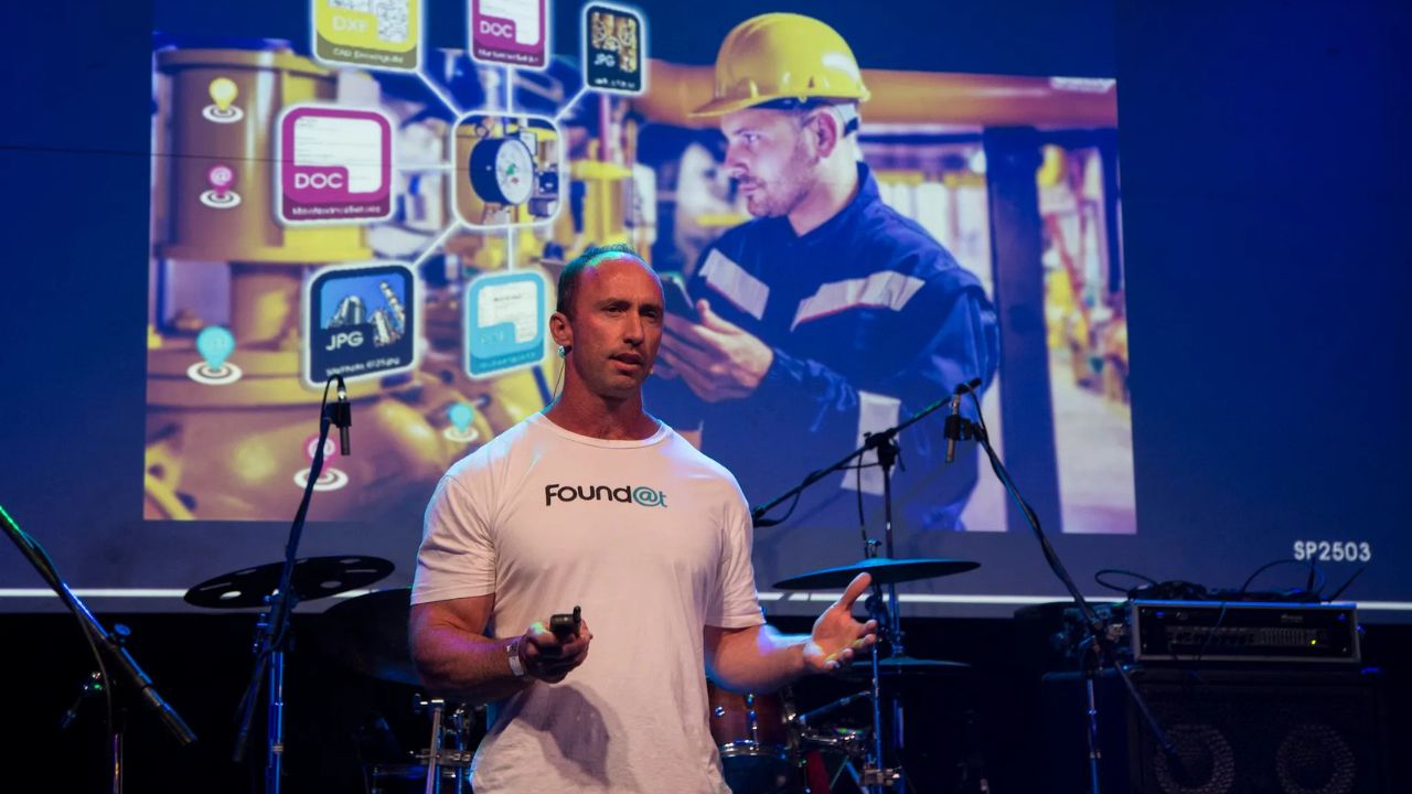
FoundAt’s proprietary solution, dubbed GoLocatAR (short for geolocated-augmented reality), dispenses with scanning entirely.
Instead, it enables users to pin digital information with up to 10-centimetre precision anywhere in the world, using advanced calibration tools.
It’s not just drawings. “Think safety procedures, induction records, inspection forms, or training content—all placed in the exact physical location they’re needed,” Leigh explains.
Field workers can retrieve or input data with a glance through their phone.
This precision is achieved in different ways depending on the environment:
- Outdoors: The platform integrates with Google Street View to triangulate the user’s location to within ~30 cm in built-up areas—ideal for infrastructure, utilities, or telecommunications.
- Indoors: FoundAt uses a proprietary QR calibration system. A single QR code placed in a lift lobby can calibrate a device’s position with 3 cm accuracy, then track movement across the floor.
Unlike other systems that require tagging each asset with a unique QR code, FoundAt can service entire floors or sites with just one.
Data control
While the geolocation is powered by FoundAt, all data remains entirely within a client’s own ecosystem, whether that’s SharePoint, OneDrive or Google Drive.
“We don’t store or control any customer data,” says Leigh.
“We’re simply a visualisation layer, like an email or browser window into their secure environment.”
This flexibility means companies can share or restrict access in line with their own policies, maintaining complete sovereignty over sensitive documents.
Although in soft launch, FoundAt has already garnered interest from a wide range of industries including mining, transport, commercial construction and asset management.
“The technology is sector-agnostic,” says Leigh. “It’s just as relevant for a water utility as it is for a commercial property group.”
Through its involvement in the REACH Proptech Accelerator, FoundAt is also engaging with commercial developers exploring new ways to visualise pre-construction assets.
For example, buyers could stand at a future development site and see a full-scale AR view of the completed building, placed accurately within the real skyline.
Interior virtual tours can also be layered on top.
From concept to commercialisation
The original patent for GoLocator was filed in 2019. But after the disruptions of COVID, serious development only began in 2023 following a modest capital raise – well below what big tech firms would spend on equivalent AR platforms.
“Apple or Google might drop tens of millions on this. We did it for less than one,” Leigh says.
Technical integration was one of the biggest hurdles.
“Getting tools like Google Street View, Unity and React Native to speak to each other took serious effort,” he says.
“But we had to get it right, because the legacy systems just weren’t working on active sites.”
Now, five years later, the system is live and available for trials.
FoundAt is officially open to customer onboarding, with early adopters gaining access to one of the most robust AR platforms ever built for field operations.
Not just another digital twin
While FoundAt shares some similarities with digital twin concepts, the comparison ends at surface level.
“We’re much faster and cheaper to implement. No 3D models. No special headsets. No heavy hardware,” says Leigh.
“And we work in the real world, not just in a simulation.”
The United States Patent and Trademark Office has now signalled approval of FoundAt’s core technology, a milestone that paves the way for future international expansion.
While the company is focused on Australia for now, inbound interest is already coming from North America, Southeast Asia, and Africa.
The next phase for FoundAt includes capturing case studies from live clients and evolving its messaging.
“It’s a challenge when the tech can do so many things,” Leigh admits.
“But ultimately, what we’re offering is simple: the ability to make your data visible, accurate and useful – wherever and whenever you need it.”